The Drummond Island CommunityCommonly asked questions about Drummond Island
|
Please note that bowling is no longer available on Drummond Island.
Community Organizations include:
|
History of Drummond Island
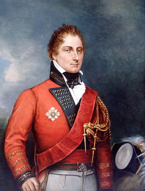
General Sir Gordon Drummond
Painting by George Theodore Berthon (1806-1892) |
The township and island are named after Gordon Drummond, who was the first Canadian-born officer to command the military and the civil government of British Canada. As Lieutenant Governor of Upper Canada, Drummond distinguished himself on the Niagara front in the War of 1812 and later became Governor-General and Administrator of Canada. The Ojibwe name for the island is Potagannissing.
The history of Drummond Island dates back centuries, but more recent history of the past 200 years relates to the British occupation of the island during and after the War of 1812. The island was the last British outpost on American soil following the Treaty of Ghent (1814). It was finally returned to American hands in 1828. Drummond Island is the only island in the Manitoulin island chain which is part of the United States. British and American negotiators to the 1814 Treaty of Ghent ended the war by offering no territorial concessions to either side, but returned to those boundaries set by the Treaty of Paris of 1783. But, in order to resolve territorial claims that had precipitated the war, negotiators at Ghent established a process whereby commissioners would survey the boundary to determine the borders envisioned in the original treaty. |
Beginning in August 1820, two teams of surveyors, including British explorer and cartographer David Thompson, mapped the area of St. Joseph Island, Drummond Island, and Lesser and Greater Manitou Islands (today Cockburn and Manitoulin islands). Mapping this corner of Lake Huron was a challenge given that little was known about the shores and depths of the channels between the islands. The agent for the United States survey team, Major Joseph Delafield, complained, "No map that I have seen has any truth as it respects the position of Drummond's or the other islands about St. Marys. We entered this bay without a pilot, but are told we cannot proceed up river without one."
Based on the surveys taken in the summers of 1820 and 1821, and guided by the Commission's two principles that the boundary would not divide islands and that the number of islands would be apportioned equally between the two countries, in November and December 1821, commissioners agreed to grant St. Joseph Island and Cockburn Island to Canada and Drummond Island, which lies between them, to the United States. Importantly, it also placed the border along the western shore of St. Joseph between it and St. Tammany (today Neebish) Island.
But, the commissioners were unable to agree on where the border should go upon exiting the channel between St. Joseph and St. Tammany islands. This question was not settled until the 1842 Webster–Ashburton Treaty finally established the boundary "along the ship channel between Saint Joseph and St. Tammany Islands, to the division of the channel at or near the head of St. Joseph's Island [sic]; thence, turning eastwardly and northwardly, around the lower end of SE George's or Sugar Island" so as to assign Sugar Island to the United States.
Historical References
- Carroll, Francis M. (Fall 2004). "The Search for the Canadian-American boundary along the Michigan frontier, 1819-1827: The Boundary Commissions under Articles Six and Seven of the Treaty of Ghent". Michigan Historical Review. 30 (2): 77–104.
- "Reports of International Arbitral Awards: Declaration and decision of the Commissioners of Great Britain and the United States, under Article VI of the Treaty of Ghent of 1814, respecting Boundaries, relating to lakes Ontario, Erie and Huron and River St. Lawrence. 18 June 1822". VOLUME XXVIII pp.11-16. United Nations. Retrieved 20 February 2013.
- "British-American Diplomacy: The Webster-Ashburton Treaty". Yale Law School: Avalon Project. Retrieved 27 February 2013.
|
Purchase Visitor's Guide for $6
|
© COPYRIGHT 2017-2024. ALL RIGHTS RESERVED.